Saturday, December 11, 2010

Norton Sound

The Norton Sound is an inlet of the Bering Sea on the western coast of Alaska. For centuries the Norton Sound area has been home to the Yupik and Inupiat people. It is the boundary between the two groups; the Yupik live to the south and the Inupiat to the north. There are several villages along the shores of the Norton Sound which include Elim, Golovin, Stebbins, White Mountain, Koyuk, Shaktoolik, St. Michael and Unalakleet. I have been to 5 of these villages and they are all exceptionally beautiful. Living in an area that is surrounded by the Norton Sound and having a view of it from my bedroom window has given me the chance to watch it change through the seasons.


The Sound has gone from a beautiful body of water filled with salmon to an icy winter wonderland in just a few months. When I first arrived in Stebbins this summer I would walk along it’s lovely beaches and would help pull salmon out of it’s waters. Now I walk on it’s frozen surface to the massive icebergs that have formed among the frozen layers. The Norton Sound is an extraordinary area of the world. It’s beautiful in the summer when the sun barely sets behind it before it quickly rises again and when you can see and hear it’s waves crashing on the beach. The Norton Sound is even more spectacular in the winter when the sun barely rises before it quickly sets behind the Sounds endless miles of frozen water.

Sunday, October 24, 2010

Flying

A thin blanket of snow covers the ground as I walk to the school to get ready to depart for training in another village. We finally get the call that the plane will be here is about 15 minutes. I put on my snow pants, insulated boots, down jacket, hat and gloves in preparation for the flight. I hop in the back of the truck and get a ride to the gravel airstrip just outside of town. During the winter they suggest that you wear all your winter attire when you fly just in case the plane crashes or you get stranded at an airstrip. Not a very comforting thought when you are boarding a tiny 4-passenger plane that is about to take off on a gravel runway that is covered in snow.


When most people think of flying they think of large airports, long security lines and big airplanes. Most people dress nice or in business attire when they fly and pack light because of baggage charges. This is not the case when flying in the bush. When flying in rural Alaska you don’t have to wait in long security lines, there are no airports, you fly on small airplanes and there are no extra baggage charges - comfort is more important then style and you pack light because there might not be enough room on the plane. However, flights are rarely on time and sometimes you are waiting for a flight for a few hours.


A bush airplane is an aircraft that is used in remote, undeveloped areas of the world where there is an insufficient road system. They are primarily used in the African and Alaskan bush, Canadian tundra, and the Australian Outback. All bush planes have some similar traits that include:


  • High wings for better ground visibility.
  •  Landing gear with two large main wheels and a small rear wheel in order to increase prop clearance and to help when taking off and landing on rough-surfaced runway.
  • Characteristics that help bush planes take off and land on short runways.
  • Since it is not uncommon for bush planes to have to land and take off in areas that no airplane has been before they are equipped with tundra tires.
  • Removable floats and skis so they can operate on water or snow.


The most well-known bush aircrafts are the Fairchild American Pilgrim 100 A and B, Noorduyn Norseman, the Cessna 180, Cessna Caravan and 206/207, Douglas DC-3/C-47, DHC-2 Beaver, Piper Super Cub, Aviat Husky, Antonov An-2 and Pilatus Turbo Porter PC-6.

These are the facts about bush planes - flying on one is quite a different experience. Planes are a natural part of life out here in the Alaskan bush. In order to go shopping, see a doctor, compete with other schools in sporting events, or just to go see a movie you have to fly. The first time I flew on a bush plane I was a little uneasy, but I have now been on so many that it has become more normal. I actually now like flying on bush planes because you always have a window seat and it gives you the opportunity to see some of the beautiful Alaskan wilderness.


Sunday, October 3, 2010

Life In The Bush

alaska travel
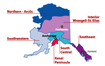
Alaska is divided into six geographical regions: Southeast, Southcentral, Anchorage, The Interior, Fairbanks and The Bush (Northern Artic).

Southeast
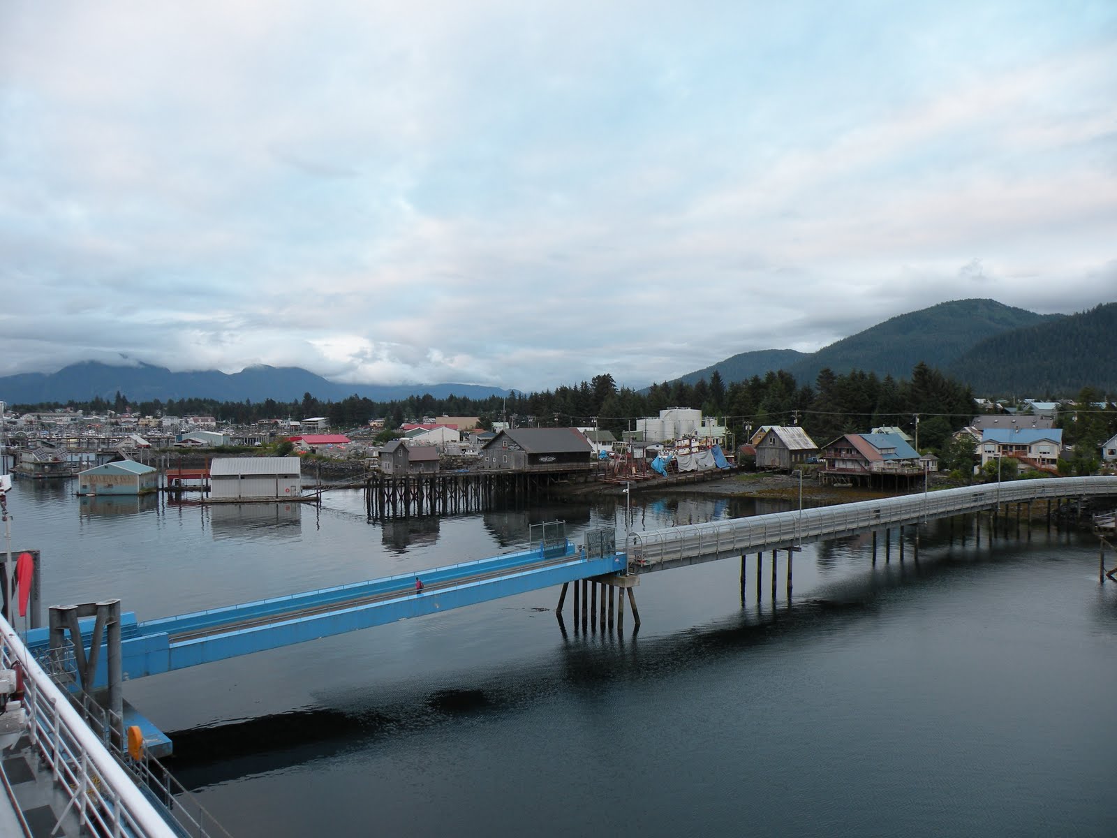
Also known as the Panhandle, Southwest Alaska is a 500 mile coastal strip made up of hundreds of islands. The inside passage is a transportation route through these islands.

Southcentral
The Southcentral region curves from the Gulf of Alaska, past Prince Williams Sound to Kodiak Island.

Anchorage
The Anchorage Bowl holds almost half the state’s population.

The Interior
The Interior includes three major roads – the George Parks, Glenn and Richardson highways – that cut across the center of the state and pass a number of forests, state parks, and recreational areas, including Denali and Wrangell.

Fairbanks
Fairbanks, Alaska’s second biggest city, is in the flat valley floor formed by the Tanana and Chena rivers. This is the best place to see the Northern Lights.

The Bush
The last region is The Bush, it is larger than the five regions put together and is separated from them by vast mountains and powerful rivers. The Bush covers a wide range that includes the Brooks Range, Artic Alaska, Western Alaska on the Bering Sea, the Alaska Peninsula, and the Aleutian Islands. I spent my fist two weeks in Alaska traveling through the Southwestern region and exploring Anchorage. I am now living in The Bush and loving it!

I am living in the Western part of The Bush region on the Bering Sea. I get to watch the sun set into the Bering Sea from my bedroom window every night (that is when it sets before midnight) and a few weeks ago I went swimming in it. The majority of the Bush is made up of small, remote native villages that can only be reached by plane or boat, and endless stretches of untracked wilderness.

Historians believe that the first Alaskans migrated from Asia between 15,000 and 30,000 years ago. The nomadic groups followed the animal herds. The first groups to come over were the Tlingit and Haida tribes, who settled in the Southeast region and the Athabascans, who settled in the Interior. The other two major groups were the Inupiat, who settled the northern coast (they are also called the Inuit), and the Yupik, who settled southwest Alaska. Life was harder for the Inupiat and Yupik tribes than the tribes further south. The cold winters and cool summers forced them to develop a highly effective seal-hunting culture to sustain life in the harsh regions of The Bush, which they maintain today.


The village I am living in is primarily Yupik. Many of the tribes lost some of their culture when fur-traders and whalers started coming into the villages but they have been able to keep some of their culture intact and it has been interesting to see. I have been in the village for about a month and I have seen people out berry picking, there are nets all along the beach for salmon and I have heard kids talk about their hunting trips. I have also seen Eskimo dancing (which is beautiful). I am looking forward to seeing both the Iditarod and Potlatch (Eskimo dancing festival) in March. I have also picked up a few Yupik words. Life is both simpler and more complicated here, but it is a beautiful place to live.


Transportation

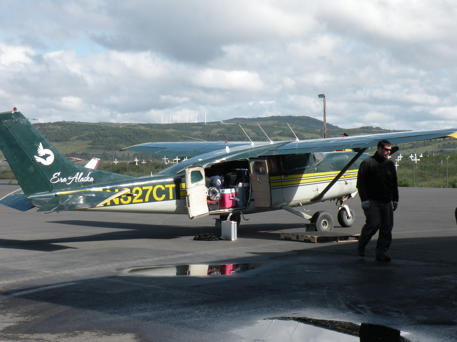
The only way in and out of my village is by plane. I have never been on so many planes in such a short amount of time. I have also never been on planes as small as some of the Bush planes I have been on in the past month. It seems like every plane I get on gets smaller. Planes are just a normal part of life in The Bush and the majority of the villages have a small airport. The smallest plane I have been on was a four passenger plane. It has taken a while to get used to the Bush planes and the gravel landing strips. I have been on about ten planes in the past couple of months so I am slowly getting used to flying everywhere I need to go - I actually kind of like it. There are not many places in the world where school sports teams take planes to travel for meets.

There are roads in the village and one ten mile gravel road that leads to another village, but these are the only roads on the island. The main mode of transportation is by Honda (4-wheeler) or in the winter snow machine. There are a few trucks on the island, but most people just use Hondas.

Food

I have had wild blueberries and all the fresh salmon I want since I have been in Stebbins. There is a small market in the village where you I can get essentials and a little bigger market in a nearby village. I have been able to get milk and eggs at these stores, which I have been very happy about. The items I like are about double the price, but so worth it. I usually pay about $6 for a half gallon of milk and a few weeks ago I paid $3 for a Dr. Pepper. All the teachers also do a big food order from a company that ships to The Bush and we get produce shipped from a farm in Oregon, so I don’t have to live off of canned food. The best thing about being right on the Bering Sea is all the fresh salmon.


Weather

The weather in Stebbins has been great! At the beginning of August when I first arrived in Alaska I spent several days in the Anchorage area and it was rainy and cold the entire time. I figured I might as well get used to it because this is the way it’s going to be for a while – it’s not. There are days that are cold and rainy, but they haven’t lasted more than a few days and most of September has been very sunny and warm. By warm I mean in the 60s, which is what I consider the perfect temperature.


Light

When I first arrived in Alaska the sun would set around 1 a.m. and would rise around 6 a.m. It took some getting used to, but I found that I could get so much done in one day. I didn’t get much sleep the first month, because I would be doing something and didn’t even realize that it was midnight. The light has not lasted as long as I would have hoped and every night we get less and less light. Right now we have normal days, the sunsets around 9:30 pm and rises around 8:30 a.m. That just means we are slowly heading to the long dark winter. I want to experience everything Alaska has to offer so I am looking forward to experiencing the dark cold winter.


-

Villages in The Bush

The Bering Strait School District consists of 15 schools that stretch along the Bering Strait, not including Nome. I have been to four villages in the Bush so far and everyone has been different and unique. They are all small, remote villages with their own unique beauty.

Stebbins
Stebbins is located on St. Michael Island. It is considered an island because it is surrounded by water on three sides and a river cuts it off from the main land on the fourth side. There are only two villages on this island Stebbins and St. Michael. The landscape is made up of tundra so there are no trees, just little bushes and a lot of water. There are some amazing sunsets and sunrises here in Stebbins. I get to watch the sunrise every morning from my classroom and I get to watch the sunset every evening from my bedroom window. I love living so close to the ocean.


.
.
St. Michael

Mt. Michael is the only other town on the island and the only town we have regular access to. It is a little smaller than Stebbins but it has a larger store, so we often make trips to the store in St. Michael. It is only 10 miles from Stebbins so its landscape is similar.


.
.
Unalakleet
The district office is in Unalakleet so I spent my first three days in The Bush sleeping in the school for new teacher training. We travel to Unalakleet a few times during the school year for training. Most flights to Anchorage go through Unalakleet because they have a larger airport, with a paved runway. It is a larger village with tundra and a hill with several windmills on it.


.
.
.
.
White Mountain

White Mountain is a smaller village located near Nome. It is about half the size of Stebbins. It isn’t surrounded by water like Stebbins, but there are pine trees. I went to White Mountain for a cross country meet and the kids were amazed by the trees because there aren’t any in Stebbins. The course they ran was beautiful because it went through the massive forest of pine trees.


.
.
.
.
Koyuk

Koyuk is by far the prettiest village I have seen. It actually ranks up there in the top ten prettiest places I have ever seen. It is located north of Stebbins, near Nome. I went to Koyuk for a cross country meet. We arrived early Saturday morning, right as the sun was rising. We walked the course as the sun slow rose in the sky. There was a little fog that rolled across the tundra and the water was so still it looked like glass. Koyuk has the water, the trees, and the mountains in the distance – it is a strikingly beautiful area.


The Bush is a beautiful and mysterious place to live. I am so glad I moved up here! Although I am very isolated I work with some amazing people that I am so thankful to have in my life and I live in a stunning part of the world that not many people get to see. There are some challenges that I have faced here and I have had to make some lifestyle adjustments, but I am so thankful to be here.
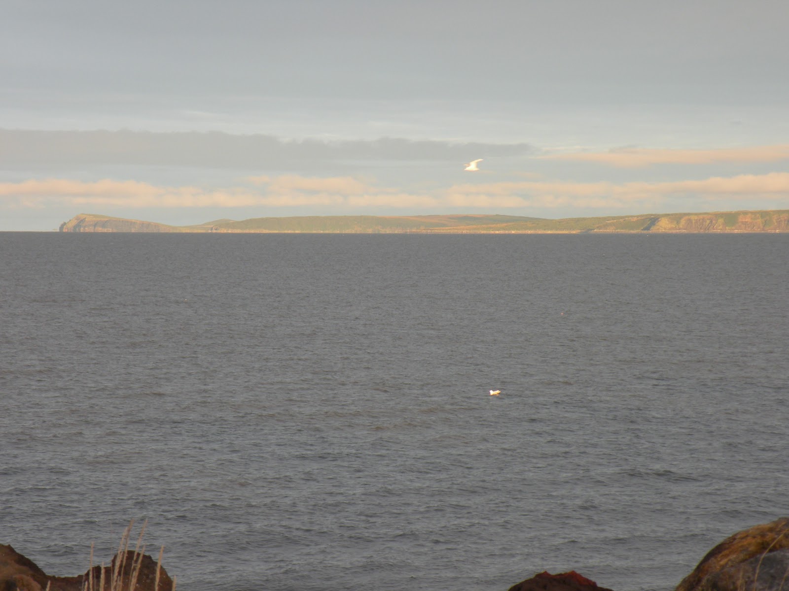


Tuesday, August 10, 2010

Alaska and The Inside Passage

Alaska is a mystic and mesmerizing part of the world with a vast landscape, majestic mountains that jet straight up from the sea, and an abundant amount of wildlife. Along my journey up the inside passage I slept in the solarium at the back of the boat so that I wouldn’t miss any of Alaska’s beauty. I spent my nights watching the radiant sun slowly set into the ocean or behind the mountains and I was woken up by the suns warm glow every morning. I spent my days at the back of the boat meeting new people from all different walks of life and watching for natures amazing animals.

I saw several humpback whales along the way. Everyday I stood at the back of the boat looking out at the depths of the ocean. Every once in a while I would see a buff of water shoot up from the still water. Then the whale would lift it’s tale out of the water to begin to dive. From a distance I was able to see a few come all the way out of the water, which is an incredible event to watch. Whales are remarkable animals.

The humpback whales were the most exciting animals to see, but I also say a black bear walking up the road, several bald eagles, a sea otter and some Dall sheep.

The inside passage is a watery transportation route among named and unnamed islands off of British Columbia and into Alaska. The route starts in dense spruce forest and deep cascades and soon turns into deep fjords that twist and turn and ends in stunning blue glaciers. The ferry from Bellingham to Juneau stopped at three ports along the way: Ketchikan, Wrangell and Petersburg. The ferry from Juneau to Whittier stopped in Yakutat.


Ketchikan
The first port along Alaska’s inside passage is Ketchikan. Ketchikan is beautiful, but a little too touristy for me. All of the major cruise liners stop in Ketchikan, so they get thousands of tourists there everyday.

Wrangell
Wrangell is a small town located on Zimovia strait. Some of the attractions in Wrangell are petroglyphs, a totem park, and a replica of an 1894 tribal house a USGA-rated golf course. It also offers flightseeing and hiking.

Petersburg
Petersburg was a fish camp site before a Norwegian immigrant built a salmon cannery in 1897. Many of his countrymen followed and soon after a Sons of Norway hall was built. While in Petersburg you can take a boat excursion to listen to whales sing or you can watch seals sun themselves on ice bergs. In May there is the Little Norway Festival and Salmon Derby. We didn’t have time to get off the ferry in Petersburg, but it looked like a quant little town.


Juneau
The capital of Alaska is a breathtaking town. Juneau has dark evergreen forests and endless waterfalls flowing from its mountains. The town is in a channel surrounded by mountains and rainforests. Juneau was Alaska’s largest city until World War II closed its gold mines and it is the only state capital not accessible by road.

Yakutat
If you ever feel the need to go surfing in Alaska Yakutat would be the place to go. Due to its big waves and uncrowned beaches Yakutat was named one of the five best surf places in the nation by Outside Magazine. The woman that I talked to at the coffee shop in town said the pro surfers start coming in September and hundreds of surfers from all over the world visit Yakutat every summer.


Whittier
Whittier was our last stop on the ferry and my favorite town along the inside passage. It is a small town of only 300 people, and constantly covered by clouds, but it is surrounded by impassable mountains and because of all the rain it is very green. The only way to get in or out of Whittier by car is through a one way tunnel. Until recently you could only get to the town by sea or train. In 2000 the 2.5 mile railroad tunnel under the mountains was enlarged to allow cars and trucks. Just outside of Whittier we hiked to a mystical blue glacier. The glaciers in Africa were amazing because they were so big, but the glaciers in Alaska are an exceptional crystal clear blue color to them.


Kenai
The drive from Anchorage to Kenai has been ranked one of the top prettiest drives in the nation and it was truly stunning. There are mountains covered with glaciers and a sparkling blue river of glacial water running along the road. Of all the towns I saw in Alaska Kenai was one of my favorites.

So far Alaska is one of the prettiest places I have ever been and I am looking forward to having at least a year to explore this great state.


Traveling is great not only because of the different places you get to see but also because of the different people you get to meet. I have met some truly fascinating people during my travels. My journey up the inside passage was no exception.

There were all different types of people on the ferry with many different life stories and all of them were going to different parts of Alaska for different reasons. I am so glad I met some of them and was able to hear their life stories. There are some amazing people in the world.

Sunday, July 25, 2010

Beaver Creek XTERRA Triathlon

A triathlon is a multi-sport endurance event consisting of swimming, cycling and running. Triathlons vary in distance. The main international race distances are Sprint distance (750 m swim, 20 km bike, 5 km run), intermediate also known as Olympic distance (1.5 km swim, 40 km ride, 10 km run), the Long Course also known as the Half Ironman (1.9 km swim, 90 km ride, 21.1 km run), and Ultra Distance also known as the Ironman (3.8 km swim, 180 km bike, and a marathon 42.2 km run).


Another type of triathlon is the XTERRA triathlon. Unlike a traditional triathlon, which is done on the road, XTERRA triathlons are done off road (mountain biking and trail running instead of road biking and running). The XTERRA is the best known series of off-road triathlons, and is considered to be the de-facto championship of the sport. There are two primary divisions in XTERRA races, professional and age-groupers. The professionals compete for cash prizes and sponsorships and the age-group division is for the rest of us, ordinary people who want to still compete. Both divisions accumulate points during each race. They also offer a sport version which is half the distance of the of the full XTERRA race. Because they are off-road races the distances can vary depending on the terrain.

The Beaver Creek Mountain Championship is an XTERRA triathlon located near Vail, CO. The full course is a 1 mile open water swim, 15.5 mile mountain bike with 3,600 feet of elevation gain and 5.75 mile trail run with 1,300 feet of elevation gain. On July 17, 2010 I finished the Beaver Creek Mountain Championship XTERRA triathlon. There are three things that I have done in my life thus far that stick out as very physically challenging and this was one of them. I didn’t do as well as I wanted, but it was a great experience. It was a beautiful day and it’s always great to be in the mountains. The race started at the lake in Avon, CO, then climbed high above the town through the Beaver Creek ski slopes and ended with a beautiful run through the aspen groves. I like challenging myself and this was defiantly a challenge but if I do another triathlon I think I will do an Olympic distance at sea level.

Wednesday, June 9, 2010

Alaska

My next adventure is to Alaska! Starting in August I will be spending at least the next year in a small town on the Bering Strait. I am moving to the village of Stebbins to teach second grade. Stebbins is located southeast of Nome, on the north side of St. Michael Island, which is on the south side of the Norton Sound in western Alaska. The population in Stebbins is around 600 and 95% of the population is Native Alaskan. In the summer there is about 20 hours of light a day and in the winter there is about 4 hours of light a day. I have heard that the all day of light is the hardest to get used to, but people have given me suggestions to help with this. One suggestion is to put aluminum foil on my windows. The temperature ranges from 60° F in the summer to -10° F in the winter. The weather and amount of sun light will take some getting used to - it is all part of the adventure.

Stebbins is located in a part of Alaska called the Bush. The Bush encompasses small, remote native villages and miles of untracked wilderness. It ranges from the city of Nome, on the Bering Strait, to the northern most city in the Untied States, Barrow and along the Dalton Hwy to Fairbanks. There are very few roads in this area of the world, so the only way to get around is to fly, float or walk.

Alaska is 586,412 sq. miles. I am leaving two weeks before I start work in order to explore the great state of Alaska a little before I move to this small remote area of the world. I am taking the Alaska Marine Highway Ferry from Bellingham, WA to Juneau, AK and then from Juneau to Whittier, AK. The Alaska Marine Highway follows the famous Inside Passage. The Inside Passage is a coastal route with a series of passages between the mainland and coastal islands. The passage starts in the Puget Sound and extends through coastal British Columbia and the Alaskan Panhandle. It looks like a beautiful way to see the coast on my way to Alaska.

My adventure to the great state of Alaska will begin at the end of July! I will continue to blog about my trip through the Inside Passage and life in a small, remote village out in the Bush of Alaska. I can’t wait!!!

Tuesday, June 8, 2010

Utah's Desert


The mountains have always been my favorite places to hike, but there are some truly beautiful and unique areas in the desert. One of these places is the Grand Gulch. Located in southeast Utah, the Grand Gulch is a beautiful, historic area of the United States. Throughout the canyons and mesas of the Grand Gulch there are several cliff dwellings and petroglyphs. These sites are still fairly in tacked and they give us an amazing look into the life of the Anasazi. The Anasazi thrived in the Grand Gulch area between 700 and 2,000 years ago. As you hike along the canyon you can see a piece their history hidden in the canyon walls.


Not only is the Grand Gulch a magnificent place to find Anasazi cliff dwellings and petroglyphs, but its beautiful canyon walls and lush oasis make this area a stunning place to see. The canyon walls are full of a multitude of browns and tans that are sometimes cast in the shadow of the lush, green willow trees that stand tall around their scarce water sources. Nature and history are so interesting and in the Grand Gulch you get to experience both. Whether I am on top of a mountain or down in a canyon, the beauty of nature always seems to amaze me.

Perfect Kiva

Kivas were used for religious ceremonies. Perfect Kiva has been restored and is one of the most interesting kivas on the Colorado Plateau.


The Green Mask


Snow in May

Followers